The rental car shuttle bus that was supposed to pick me up at 9:00a was a no-show, and I stood outside while Angela and the boys left for, enjoyed and then returned from breakfast. Another waiting customer from Hong Kong was absolutely convinced that I was his driver and approached me multiple times saying, “You’re here for me,” while showing me his printed receipt. It took a while, but I finally convinced him I wasn’t the right guy.
After finally getting our car we headed north out of the city along Route 1, the famous Ring Road, until we came to a long tunnel at Hvalfjörður. I pretty quickly picked up the road sign nuances and the general rules about speed, crosswalks, traffic circles and single lane roads. Soon at Borgarnes we headed west off the main route so we could visit the West Fjords.
LAND OF FIRE AND ICE
The Ring Road was completed in 1974 and is mostly paved – only a few stretches are still gravel or dirt (more on that later). Our exit onto Route 54 led us toward Snæfellsnes and the Snæfellsjökull glacier – the setting for Jules Verne’s novel “Journey to the Center of the Earth.” The drive coiled through a line of craters near Eldborg. Initially our ambitions steered us off the road to climb the most prominent crater, a sharp-edged rocky exit wound that rose distinctly just off the main highway. But the parking lot and trailhead weren’t enticing for a still-jetlagged crew, plus we were a bit pressed for time after the rental car snafu.
Past grass-covered hills and between breaks in the mountain spurs that press to the rocky shore, we could see the Snæfellsjökull glacier. The shape gives it away as volcanic, and once you get closer you can see clear signs of glacial and volcanic activity. Volcanic evidence is everywhere in Iceland – black lava rocks, clear patterns of flow down mountains, cinder hills, steam rising along roads and sulfurous yellow clay spots barren of plant life.
We were interested in driving to the top, but hunger beat curiosity and we went in search of food. We found plenty of interesting rock formations down at the town of Amarstapi marina, but not a good café. A place had been recommended to us in Hellnar and we drove down a gravel road to a lovely cove with a sea cave and arch where a little café was perched overlooking the sea.
THE SPORTS ILLUSTRATED SWIMSUIT MODEL
Oddly there was a film crew at this isolated place. At the water’s edge, two stars and 20 or so crew members (one with a drone camera) scurried about. While enjoying a light lunch of quiche, salad, bread and waffles, we watched the action. We speculated on what they might be filming – maybe a soap opera or some local drama – but the actress had a very attentive assistant bringing her drinks and different shoes for climbing over the rocks, so we figured she might be bigger than a local celeb. Plus she was abnormally gorgeous – something that Ronan seemed very aware of. I didn’t recognize her, but Angela knew it was Chrissy Teigen. She was filming an Uggs commercial. Ronan googled her on his phone and realized it was a noteworthy sighting.
After lunch we headed to a secluded beach of black stones with a trail leading from the craggy overlook through a black lava colonnade down to the beach. We lost track of time sitting on the rocks and watching the waves heave and pound so strongly we could hear it vibrate the stones.
Later we circled back to Snæfellsjökull, with a plan to drive up and over the road that led to our next destination. Halfway up the side of the 18% grade road of large, slick stones, no turnouts, and steep treacherous falloffs, I made the call to return to pavement. Had we been in our F-350 it would have been no problem, but in a light-weight Dacia Duster it was a no-go.
Back on real road we wrapped around the peninsula to the Hotel Ólafsvík in the village of the same name. It was a small town with no places to eat except the hotel, and it was closed that night so they could paint the interior. The hotel manager suggested a little place called Kaffi Sif in Rif, which served traditional Icelandic fare – Plokksfiskur, fish soup and the like. The food was okay, but the service was outstanding and the boys enjoyed reading some Icelandic kids’ books.
ROADSCHOOLING ON A FERRY
We were up early as we needed to make a 9:00a ferry across Breiðafjöður Bay. It was crisp — around 7 degrees Celsius with clear skies. Since the town of Ólafsvík is pressed so tightly against the towering ridge of Snæfellsnes peninsula, the sunrise was hidden giving the town an extended and surreal dawn.
Breakfast didn’t officially start until 7:30a (the time we needed to leave by in order to make the ferry), but they let us in early to wolf down toast, cereal and coffee before hitting the road. The villages we passed through were small and quiet at that time of day, with most of the fishermen already out on the sea. At Stykkishólmur we loaded our car onto the ferry, grabbed our backpacks and schoolbags and headed for the dining hall deck for some roadschooling (ferry-schooling?).
The trip was supposed to take around 3.5 hours, pausing briefly for a stop at Flatey, a small island in Breiðafjörður Bay just north of the halfway point. School went well although the free coffee refills made me jittery while I taught Asher. We landed in Brjánslækur and drove along the narrow road wedged between beaches to the south and steep hills on the north. A danger of driving in Iceland is that sheep that grazing along the roads will get spooked and inadvertently rush across it. This stretch of road had a lot of farms, a lot of sheep and required a lot of attention to navigate safely.
Our destination for the day was the Foss Hotel in Patreksfjörður, but we took a detour about 10kms south of town to drive out to Látrabjarg – the western-most point in Iceland and thus, Europe. It is also known as a good spot to see puffins nesting in the thousand-foot tall cliffs. We stopped for a snack along the way, and the café was also a museum (there are a several homemade museums in Iceland, usually built around one person’s obsession with collecting things). This one had a U.S. Navy DC-3 in parts outside.
CRAWLING TO THE EDGE OF THE CLIFF
The road was rough and jostled and bounced the car, heavy with all our belongings for a three month excursion. It was also laden with blind corners and crests. We drove past an enormous fjord filled with fine sand and grasses that reminded us of an undeveloped Outer Banks of North Carolina. At the point, the Bjargtangar lighthouse sits close to the edge of cliffs that are more than 300 meters high. It is clear that the cliff continues to recede and will eventually drop the lighthouse into the Atlantic Ocean.
The cliffs are so dangerous that the guidebooks insist one “crawl to the cliff’s edge in order to get a good picture” of the puffins. Collapses are fairly common and crawling distributes body weight more evenly…how comforting. We decided simply to stay away from the edge – especially me as I had the car keys and was the only one who could drive a stick. We walked around the area and admired the wild beauty, but alas saw no puffins.
HÁKARL AND BLACK DEATH
After a long day we arrived in Patreksfjörður at the Fosshotel Vestfirðir. It was a modern hotel with nice interior décor, sitting areas and comfortable rooms. Angela found a highly recommended restaurant (there weren’t many options in a town of fewer than 800 residents) called Heimsendi Bistro, a small shack at the harbor set amidst abandoned buildings and rusting equipment. Inside it was very hip and the food was great.
Back at Fosshotel, I took the boys downstairs to the bar so they could work on their journals and I could have a beer. The lady sitting next to me ordered Hákarl and Black Death (aka Brennivín) on a self-inflicted dare with her partner, who couldn’t bear to watch as she consumed it. Hákarl is fermented shark and the food that Anthony Bourdain said was the “single worst, most disgusting and terrible tasting thing” he has ever eaten. Look it up and you’ll understand why. Brennivín is unflavored Icelandic schnapps and is the default chaser to Hákarl.
I stuck with my beer.
FISH HO– USE OR VIKING VICTORY HALL
We were still trying to get into a sleep routine and neither Angela nor Ronan slept well that night, so Asher and I went down to breakfast alone while they rested. Most places offer a good selection of breads, cereals and eggs. Here Asher discovered that the hotel had awesome chocolate croissants – one of his personal favorites.
Once everyone was awake we loaded the car and headed northwest over the moorlands. The drive across the high heath covered in heather, gorse and flowers provided breathtaking views down into the fjords even on a cloudy day. The road was rocky and rough but the constant rattling lulled Ronan and Angela to sleep and they each enjoyed a good nap on the road.
Over the ridge and down into the town of Bíldudalur, we turned southeast and traveled along the lower edge of the fjords through the villages of Foss (Icelandic for waterfall) and Norðfjall (Icelandic for north mountain) until we reached Dynjandi (aka Fjallfoss). The trail for the falls takes visitors to the top tier of the cascades. We walked along the river toward the falls but didn’t get far before the rain and wind turned us back.
We passed through the town of Hrafnseyri in Arnarfjörður in the Westfjords, the birthplace of Jón Sigurðsson. Jón was the leader of the 19th century independence movement for Iceland and is currently pictured on the 500 kronur bill (worth about $5). We then cut across the base of the “fingers” of the remaining fjords separating us from our destination, the Hotel Horn in Ísafjörður. Each of the fjords offered a long view into the Northern Atlantic toward the Arctic Circle. At Ísafjörður, we skirted the water’s edge and connected onto a spit of land across Skutulsfjördur near the shipyards to our hotel.
After a long day of driving, I needed to grab a beer and read (one shouldn’t underestimate the need to decompress after driving dangerous roads all day), and walked through the village around the hotel. I found a great little place called Husid, Icelandic for house, which had fast wifi and okay beer. Angela’s discovery for dinner was a highly rated fish house called Tjöruhúsið. It was about a one kilometer walk down alleys and between storage buildings for the docks, past forklifts and weedy lots. We soon found a little park filled with anchors, whalebones and harpoon guns and our restaurant nestled to the side.
The building was a fish house built in 1781 and wasn’t well marked. The latched barn doors hardly looked like a proper restaurant entrance. Inside were long, hand-crafted wood tables with benches set for dinner. The place was full, but we found a reserved spot with our name – well, saved for a party named “Mak.” The food was served family style, with strangers sitting shoulder-to-shoulder while staff announced each course from the head of the room. Giant iron skillets of food were then placed on a serving table, still steaming and bubbling from the kitchen.
The starter course of traditional Icelandic fish soup was incredible. The main course was seven different fish dishes – plaice, cod, haddock, and more, each fried, baked, boiled or sautéed and complemented with grains and vegetables. The chef buys the fish fresh from the fishermen each day and sets the menu according to their catch. Customers don’t know what will be on the menu, but it doesn’t matter because it’s all extraordinary.
Sitting on the roughhewn benches inside a lantern-lit hall with strangers speaking German, Swedish, Norwegian, French and Icelandic made it feel like we were a triumphant Viking clan returned from battle. The beer and wine flowed, generous baskets of bread were set out, and coffee and chocolates were offered in pewter basins. Even Asher, who is usually quite particular about his food, tried and loved the plaice (a kind of fish). Ronan ate more than the rest of us combined.
We plied the cold night fog for a night cap and reading time at Husid before heading to bed.
WINDING THROUGH THE FJORDS
A fairly long drive from Ísafjörður to Drangenes again wove us through beautiful fjords and over rocky uplands with steep cliffs. Visibility was worse than on previous days – even when the low clouds broke, those higher still filtered out the sun. We passed through Skutulsfjörður, Alftafjörður, Seydisfjörður, Hestfjörður, and Skotufjörður, crossed a small one-lane bridge at Midlfjörður, then through Vatnafjörður, Isafjörður, Steinsgrimsfjörður, Bjararfjörður (lots of fjords!). The drive was filled with lovely views, but the wind and rain made traversing the higher altitudes difficult.
Once in Drangenes, we unloaded at the Guesthouse Malarhorn, a small cluster of townhouse-style apartments. The village was very small and felt the most remote of anywhere we’d stayed. Their café was open, just barely – it closed at 2:00 but at 1:50 they were still willing to feed us.
THE END OF THE ROAD
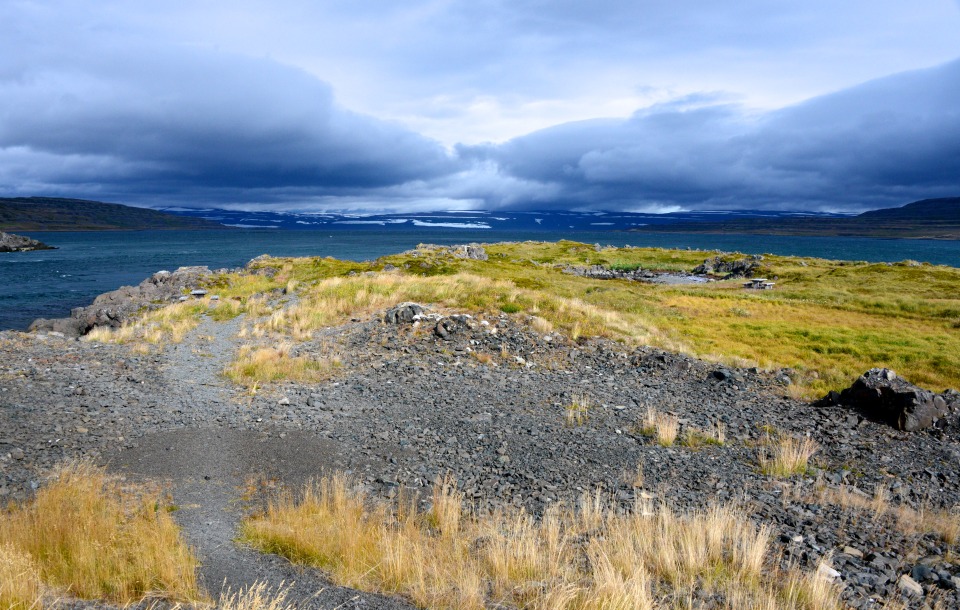
After lunch we drove the Strandir coast. We had debated this “optional” outing noted in our guidebook, but in Iceland the most amazing views are found along the dirt roads (the entire interior of the country is off limits to vehicles other than special 4x4s, or we would have explored it too). This road was especially rocky but also particularly stunning, with broad views of sheer cliffs facing the North Atlantic. It was the most harrowing road I’d driven on our adventure – several stretches had no guardrails with 200 meter drops into the ocean. To all our friends and family: I was VERY deliberate and cautious.
We drove through the town of Djúpavík, where an abandoned herring factory sits rotting away next to a beached ship pulled halfway ashore – the back half apparently lost to the elements of the sea. Along the way, we saw lots of sheep, whooping swans, and at the end of the road, a group of campers soaking in a naturally-heated pool facing the ocean.
By the time we returned to the guesthouse, I was mentally and physically exhausted from a day of extremely tough driving. After a quick bite to eat in the café we were off to bed.
CLICK ANY IMAGE TO OPEN THE GALLERY.

